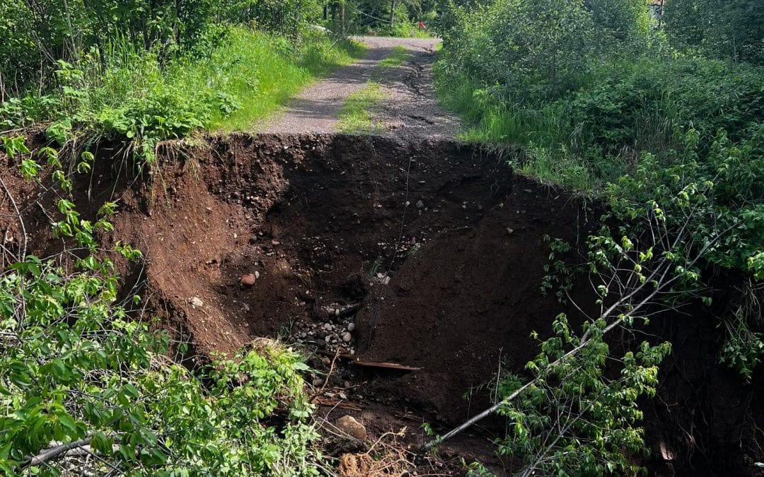

This washout at Sugarloaf Nature Center near Highway 61 is a problem for Gracie Sangmiester and her minivan. Submitted photo
More BWCA Entry Points Shut Down, Numerous Roads Remain Closed Across Superior National Forest

By Joe Friedrichs
UPDATED at 12:20 p.m. June 22: The North Arm Road, Mud Creek Road, and Echo Trail are now open. Other road closure updates from June 22 below.
SUGARLOAF NATURE CENTER – Gracie Sangmiester was excited to get a new vehicle.
A native of Pennsylvania, Sangmiester is site host at the nature center this summer, which is located near Schroeder, Minn., on a narrow spit of land between Highway 61 and Lake Superior. Her mother and grandmother were driving a Subaru Outback from Pennsylvania this week to swap it out with the family minivan Sangmiester drove out to Minnesota earlier this year.
And then the storm hit.
Tuesday night (June 18), a series of intense thunderstorms and strong winds swept across northeastern Minnesota. Large areas of land, including roads, driveways, and other infrastructure, were damaged or destroyed across Cook, Lake, and St. Louis counties by the storm system. Numerous roads, including Highway 1 just east of Ely, and entry points leading to the Boundary Waters Canoe Area Wilderness were closed this week following the severe weather.
Sangmiester’s minivan, a Dodge Caravan, is parked at the nature center. It happens to be on the “wrong side” of a washed-out road that leads from the main parking lot near Highway 61 down to the facility’s headquarters closer to Lake Superior. The washout left a crater 30 ft. wide and 15 ft. deep. When Sangmiester’s relatives arrive in a few days to swap out the vehicles, it’s not certain if the van will be able to cross over to the highway.
“That was the whole point of them coming out here,” she said of the visit from her family. “To take the minivan and leave me the Subaru. Now we don’t know if it’s going to happen.”
Sangmiester’s predicament is one of many similar situations across northeastern Minnesota this week. An estimated 300 people at YMCA camps du Nord and Widjiwagan were essentially “stranded” when the North Arm Road washed out Tuesday night near the Echo Trail, north of Ely. Private residences on the road and the Slim Lake BWCA entry point were also impacted by the destroyed roadbed, including a large washout between the staff and public entrances at Camp Widjiwagan, a staffer there told Paddle and Portage Friday morning.
During Tuesday night’s storms, a tree fell on a 9-year-old boy who was camping with his parents on Snipe Lake in the BWCA. Snipe Lake is located south of Round Lake and the Cross Bay entry point. The boy was evacuated by the Gunflint Trail Volunteer Fire Department (search and rescue) and transported to North Shore Health, the hospital in Grand Marais. In a conversation with officials from North Shore Health Friday afternoon, they confirmed the boy was transported by an ambulance to a hospital in the Twin Cities early Wednesday morning in “fair condition.”
In more storm news from this week, the city of Cook, Minn., about 45 miles west of Ely, was impacted by flooding from the Little Fork River that flows through town. Minnesota Gov. Tim Walz visited Cook Friday to assess the damage, vowing financial support from the state in the aftermath of the flooding. Paddle and Portage spoke with a staff member at the Northwoods True Value Center hardware store in Cook at 3 p.m Friday. They said the water is receding in Cook and that it’s now “phase two” of the disaster, which involves cleaning up the damage from the flood. Morale was very high, as was the case at Sugarloaf, the YMCA camps near Ely, at the hardware store in Cook.
Washed-out roads greeted some BWCA paddlers following Tuesday’s storm, including the Mudro Entry Point off the Echo Trail near Ely. Temporary repairs to Forest Road 459 (North Grassy Road) were completed Thursday afternoon by contractors using heavy equipment under the guidance of Superior National Forest engineers, according to the U.S. Forest Service. This allowed affected BWCA visitors at the Mudro Lake Entry Point parking lot to exit with their vehicles and gear, the Forest Service reported today. The repairs are only temporary; this forest road and several others remain closed to public access, according to the Forest Service.
The Mudro Entry Point remains inaccessible with BWCA permits suspended because the road access route could be washed out again at any time. A large amount of water continues to flow through area lakes, rivers, and wetlands, making road repairs tenuous and temporary, the Forest Service reports. Multiple entry points remain closed until at least June 25. As water levels start to drop, more permanent repairs can be completed, and safe access restored to affected area, the Forest Service said Friday afternoon.
Meanwhile, damage assessments and surveys continue to be accomplished across the 3 million acres of Superior National Forest roads and lands in northeastern Minnesota. Water levels on lakes, streams, and rivers continue to rise and are causing issues in many areas. This is a dynamic and slow-moving situation and some forest roads that were passable yesterday are now obstructed today, the Forest Service reported Friday. Forest Service officials continue to coordinate with local, county, and state partners as everyone in the region is experiencing the impact of the recent weather event.
Due to washouts and flooded roads several Boundary Waters Canoe Area Wilderness (BWCA) entry points remain inaccessible. Additional entry points on the Tofte Ranger District were added Friday due to washouts and rising water levels cutting off road access, according to the Forest Service. The following closures remain in place June 21 on Superior National Forest.
BWCA permits have been cancelled through June 25 for the following entry points:
–Trout Lake Overnight Motor and Day Use Motor Entry Point #1 inaccessible due to washouts and the motorized portage not being able to operate on the road/trail. Overnight paddle permits are still being issued and the canoe portage is open.
–Slim Lake Entry Point #6 inaccessible due to washouts on the North Arm of Burntside Road.
–From Big Lake Entry Point #7 inaccessible due to a major washout on the access road.
–Mudro Lake Entry Point #23 inaccessible due to a major washout on the North Grassy Road.
–Bog Lake Entry Point #67 inaccessible due to washouts and flooding.
–Island River Entry Point #34 inaccessible due to washouts and flooding.
–Isabella Lake Entry Point #35 inaccessible due to washouts and flooding.
–Pow Wow Trail Entry Point #86 inaccessible due to washouts and flooding
Recreation sites and campgrounds
–McDougal Lake Campground (Closed through June 27, 2024, will reevaluate next week)
–Pfeiffer Lake Campground (Open to High Clearance Vehicles only)
Forest roads
LaCroix Ranger District (Northwest side of the Forest, St. Louis County)
–FR 200 (200 Road)
Laurentian Ranger District (South side of the Forest, St. Louis and Lake Counties)
–FR 113 (Headwaters Road)
–FR 118 (Camp 26 Road)
–FR 122 (Langley Road)
–FR 130 (Mooseline Road)
–FR 256 (Pfeiffer Lake Road) south end of road has a washout.
–FR 272 (Sturgeon Road)
–FR 273 (Bates Road)
–FR 278 (Dewey Lake Road)
–FR 279 (Shannon Lake Road)
–FR 380 (Stoney Grade)
–FR 425 (Bundle Lake Road)
–FR 776 Linwood Lake Road)
–FR 1822 (Koivisto Road)
Kawishiwi Ranger District (Central part of the forest, St. Louis and Lake counties)
–FR 112 (Dunka River Road)
–FR 179 (August Lake Road)
–FR 459 (North Grassy Road)
–FR 1027 (Big Lake Boat Access)
Tofte Ranger District (Southeast side of the forest, Lake and Cook counties)
–FR 166 (600 Road)
–FR 172 (Wanless Road)
–FR 174 (Dumbbell Lake Road)
–FR 177 (Mitawan Lake Road)
–FR 346 (Richie Lake Road)
–FR 358 (Hoist Lake Road
–FR 373 (NW Road)
–FR 377 (Tomahawk Road)
–FR 912 (Victor Lake Road)
Affected permit holders are being notified. The Forest Service will reassess conditions and access routes again on June 24 and determine if the BWCA permit cancellations need to be extended.
Visitors are encouraged to use extreme caution on canoe routes throughout the BWCA. River and stream flows are fast moving, and portages may be affected or more difficult to find.
More rain is predicted for Friday and Saturday across the Boundary Waters region, including the possibility of more thunderstorms and significant rainfall.
Check back to Paddle and Portage for updates.
Other Recent Articles
Media’s Interest in BWCA Search and Rescue Expands Following Busy Start to Season
Two members of the St. Louis County Rescue Squad respond to a mission in the BWCA in May. Photo courtesy of St. Louis County Rescue Squad NewsBOUNDARY WATERS CANOE AREA WILDERNESS – Last month, a group of canoe campers who took hallucinogenic mushrooms requested...
Hunting Organizations Voice Concern Over BWCA Policy Regarding Dogs in the Wilderness
Bird hunting is a common activity in Minnesota, including the BWCA. Photo courtesy of Courtney Perry PhotographyBWCA – An adjustment to language used by the U.S. Forest Service has some hunters and outdoor organizations concerned about the use of dogs for hunting and...
Jiggin’ With Jess: Enjoy the Chase
Jessica-Berg Collman is a fishing columnist for Paddle and Portage. She is a guide on the Gunflint Trail. Photo by Joe FriedrichsNewsJessica Berg-Collman is a lifetime resident at the end of the Gunflint Trail. She is following her father’s legacy as a fishing guide...